Tools Training
Materials from Select Past Training Events
Coastal-Marine EBM Tools Training for Pacific Practitioners | Marine Protected Area and Ecosystem-Based Management Tools Knowledge Café
Coastal-Marine EBM Tools Training for Pacific Practitioners
James Cook University and the University of Queensland in conjuction with the EBM Tools Network Training Program hosted the EBM Tools Training for Pacific Practitioners from August 27-29, 2008, at the Magnetic Island International Resort on Magnetic Island in Queensland, Australia. Fifty-five practitioners from Fiji, Indonesia, Palau, Papua New Guinea, Solomon Islands, Vanuatu, Vietnam, Australia, New Zealand, Canada, and the United States participated in the training. The objectives of the training were to:
- Increase awareness of software tools that can facilitate coastal-marine EBM processes
- Increase effective use of EBM software tools
Training sessions were held in two tracks:
- Track A: Introduction to tools and their functionality, utility, and capacity requirements
- Track B: Tools applications, methods, approaches and techniques
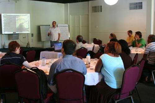
Jorge Alvarez-Romero presents to workshop participants. Photo by Sarah Carr.
Presentations from the meeting can be viewed by clicking on the links below.
Wednesday, August 27
Welcome Presentation by Bob Pressey
Introduction to EBM tools and the EBM Tools Network and overview of workshop by Sarah Carr and Dan Dorfman
Overviews of EBM tools for Marine Protected Area Network Planning, Marine Ecosystem Conservation Planning, Accounting for Connectivity, and Integrated Land-Sea Planning
Marxan and Marzone by Carissa Klein and Matt Watts
Zonation by Dan Segan
C-Plan Ecosystem Planning by Bob Pressey
A land-sea toolkit: NatureServe Vista, CommunityViz, and N-SPECT by Patrick Crist
Marine Geospatial Ecology Tools (MGET) by Jason Roberts
Emerging Tools and Approaches for EBM
Tools for dealing with risk, uncertainty, and climate-driven ecological change by Eddie Game
Return On Investment (ROI) calculations for ecosystem services tool by Michael Bode
Return on Investment by Bob Pressey
Thursday, August 28
Track A: Putting Tools for Marine Ecosystem Conservation Planning and MPA Network Planning into Practice
California MARXAN tool use case study by Carissa Klein
Marine ecosystem management in the Philippines by Rebecca Weeks
MPA networks and ecosystem conservation in Kimbe Bay by Joseph Aisti
Track B: Applying Tools for Integrated Land-Sea Planning
“Interfaces” Approach in Marxan by Matt Watts and Maria Beger
Overview of a land-sea toolkit: NatureServe Vista, CommunityViz, and N-SPECT functionality by Patrick Crist
Marine, terrestrial, and freshwater integrated ecosystem resource conservation planning by Dan Dorfman
Track A: Putting Tools for Integrated Land-Sea Planning into Practice
Framework presentation by Jorge Alvarez-Romero
Watershed Catchment effects on the Great Barrier Reef by Jane Waterhouse
Integrated assessment and planning case study by Patrick Crist
Return on Investment (ROI) case study by Carissa Klein
“Interfaces” Approach in Marxan by Maria Beger
Track B: Applying Tools for Marine Ecosystem Conservation Planning and MPA Network Planning
Overview of relevant Marxan/Marzone functionality by Matt Watts and Eddie Game
Overview of relevant Zonation functionality by Dan Segan
Friday, August 29
Track A: Putting Tools for Accounting for Connectivity into Practice
Coral reef ecosystem connectivity case study by Maria Beger
Hydrodynamic connectivity of coral reefs: a case study by Eric Treml
Track B: EBM Tools for Ecosystem Approaches to Fisheries Management
Overview and demonstration of Ecopath with Ecosim by Villy Christensen
Track A: EBM Tools for Ecosystem Approaches to Fisheries Management
Overview and presentation on fisheries ecosystem modeling with Ecopath and EcoSim case studies by Villy Christensen
Track B: Applying Tools for Accounting for Connectivity
Tools application for coral reef ecosystem connectivity by Matt Watts and Maria Beger
Connectivity tools in MGET by Jason Roberts and Eric Treml
Engaging Communities in EBM and Tool Use
Social network analysis by Ken Vance-Borland
Kimbe Bay case study by Freda Paiva
Philippines case study by Garry Russ
Informal Presentations
Presentations by Chris Bartlett and John Ronneth on marine/coastal resource management in Vanuatu and the creation of a marine reserve network on Nguna and Pele islands
EBM tools in a Community Setting by James Comley

Workshop participants on a bushwalk on Magnetic Island. Photo by Kiki Dethmers.
Marine Protected Area and Ecosystem-Based Management Tools Knowledge Café
Venue: International Marine Conservation Congress in Fairfax, Virginia![]()
Date: May 19,2009
Location: The Bistro, George Mason University
Sponsors: Conservation International and the EBM Tools Network
![]()
A wealth of tools exist to assist marine protected area managers and other marine resource managers in addressing the various issues they are tackling, including resilience to climate change, economic incentives, ecosystem-based management and networks of protected areas. Yet accessing this information has been a challenge as institutions and initiatives are dispersed worldwide. The Knowledge Cafe provided an opportunity to access critical tools for MPAs and EBM. Tool providers were available to explain their tool to participants, provide demonstrations of the tools, and discuss tool relevance to attendees’ projects with them. Tools demonstrated included guidebooks, software, websites, models, and integrated tool kits.
Download the Brochure for this Event
Tools being demonstrated:
Coastal Transects Analysis Model (CTAM) (Ratana Chuenpagdee and Ian Ivany, Coastal Development Centre, International Coastal Network) CTAM helps visualize and analyze interactions and flows between natural and human systems, with current emphasis on fisheries and aquatic resources, using information provided by users, literature, and expert judgment. Learn more at www.coastaltransects.org.
Consvalmap.org (Giselle SamonteTan, Conservation International) This interactive website provides an easy-to-use reference to all the economic valuation statistics of tropical marine resources worldwide. Learn more at www.consvalmap.org.
EBM Tools Network Website (ebmtools.org) and Database (Sarah Carr, EBM Tools Network) The EBM Tools Network is a voluntary, international alliance to promote the awareness, development, and effective use of tools and methods for EBM of coastal and marine environments and their watersheds. At this table, we will provide an overview of the range of available EBM tools and the EBM Tools Database. Learn more at ebmtools.org.
Guidebook to Incentive-based Conservation Approaches and Marine Management Areas (Heidi Gjertsen and Eduard Niesten, Conservation International) Heidi and Eduard will share their lessons-learned analysis of a global set of case studies of buy-outs, conservation incentive agreements, and alternative livelihoods projects. They will be available to discuss the applications to your situation and what key issues to consider as you plan your incentive-based conservation strategy.
Integrated Biodiversity Assessment Tool (IBAT) for business (Conrad Savy, Conservation International) IBAT for business is the first output of a shared vision between BirdLife International, UNEP-WCMC and CI, with IUCN acting as an observer. IBAT integrates critical conservation data via web-based tools to facilitate fine-scale biodiversity risk assessment by public and private sector decision-makers. Learn more about the application of this tool to marine-related development planning. Learn more at www.ibatforbusiness.org.
Marine Geospatial Ecology Tools (MGET) (Jason Roberts and Daniel Dunn, Duke University Marine Geospatial Ecology Lab) MGET is a free collection of ArcGIS tools that facilitate the inclusion of ecological and oceanographic data and analyses in MPA planning processes. MGET includes tools for acquiring and manipulating biological and remotely-sensed oceanographic data, building habitat models from field observations of important species, and modeling hydrodynamic connectivity of coral reefs. Learn more at http://code.env.duke.edu/projects/mget.
MarineMap Decision Support Tool (Will McClintock, University of California at Santa Barbara) MarineMap is a free tool that helps stakeholders visualize geospatial data layers, draw prospective MPA boundaries, share prospective MPA boundaries with other users, and generate graphs and statistics to evaluate MPAs on science-based guidelines. Learn more at http://marinemap.org/marinemap.
Marine Integrated Decision Analysis System (MIDAS) (Suchi Gopal, Boston University) MIDAS offers managers and other users of MMAs (marine managed areas) around the world the capability to analyze outcomes that result from the interaction of governance, socioeconomic and ecological factors. The users can input information relevant to their MMAs and quickly visualize the outcomes, including a map of the spatial distribution of risk.
Marine Reserve and Local Fisheries Interactive Simulation (Dan Brumbaugh, American Museum of Natural History) This simulation-based education tool allows users to experiment with the use of marine reserves as tools in fisheries management and to explore various biological and economic factors that influence population viability and fisheries sustainability. It focuses on key Caribbean fisheries species, their habitat preferences, the distribution of these habitats across the seascape, economic costs and proceeds from small-scale fisheries, and simple models of fishing behavior. Learn more at http://ncep.amnh.org/marine_simulation.
MPA EZ – the CCIF MPA Financial Management Tool (Sarah Conway and John Claussen, Conservation and Community Investment Forum) MPA EZ is a free web-and Excel-based tool that provides an overview of an MPA’s current financial situation and helps ensure that resource allocation is in-line with management objectives, financial and physical resources are used efficiently, and financing portfolios are sustainable. Learn more at http://ccif.digitalclouds.net/costmodel/authentication/login.
Open OceanMap (Charles Steinback, Ecotrust) Open OceanMap is a data collection tool used to collect local expert knowledge in support of marine spatial planning. Open OceanMap allows the user to collect and compile ecological and economic data through an intuitive 100-pennies stakeholder interview process. The tool provides interviewees with a web-based interface to review and verify information and aggregates data to ensure confidentiality. Learn more at www.ecotrust.org/ocean/OpenOceanMap.html.
ProtectPlanetOcean.org (Leah Bunce Karrer, Conservation International) This interactive website provides easy access to a wealth of information on MPAs, including a virtual library of marine resource tools ranging from guidebooks to software models to video clips. Learn more at www.protectplanetocean.org.
Practitioner’s Toolkit and Field Guide for Marine Conservation Agreements (Jay Udelhoven, The Nature Conservancy) Marine Conservation Agreements (MCAs) are increasingly being used by NGOs around the world to complement traditional efforts (such as MPAs, area-wide laws and fisheries management) to protect, manage and improve marine biodiversity and ecosystem services. MCAs include any formal or informal understanding between two or more parties in which the parties obligate themselves, for an exchange of benefits, to take certain actions, refrain from certain actions, or transfer certain rights and responsibilities to achieve agreed upon ocean or coastal conservation goals. To help field practitioners understand what MCAs are, determine if MCAs can help them meet their conservation goals, and plan in-water MCA projects, The Nature Conservancy and partners have developed an on-line toolkit and field guide for MCAs. The toolkit and field guide provide information on the basics of MCAs, phases for evaluating and implementing MCAs, country analyses, case studies and resources. Learn more at www.mcatoolkit.org.
Reef Resilience Toolkit (Stephanie Wear, The Nature Conservancy) Developed for coral reef managers, the toolkit provides guidance on how to integrate and build the principles of resilience to climate change into the design of MPAs and daily management activities. The toolkit includes guidance on management strategies such as conserving fish spawning aggregations, MPA network design, and developing coral reef monitoring programs. During the Café, we will review what is available within this new toolkit and share plans for advancing this work via training and practitioners networks. Learn more at www.reefresilience.org.
Social Network Mapping and Analysis for EBM and Conservation Planning (Ken Vance-Borland, Conservation Planning Institute) Many of the insights we get when we reflect on our conservation actions have to do with relationships—who shares information with whom and which individuals are working together. Network maps enable us to track these relationships and then work to improve information flow, innovation diffusion, and collaborative activities by improving the connectivity of individuals in the conservation network. Learn more at www.networkweaving.com/june.html.
For additional information about the Cafe, please contact Leah Bunce Karrer (l.karrer at conservation dot org) or Sarah Carr (sarah_carr at natureserve dot org).
NatureServe Vista® Presentation by Patrick Crist
Demonstration of NatureServe Vista® by Patrick Crist of NatureServe (September 30, 2008). This webinar provides an overview of NatureServe Vista, a decision support system for conservation planning that integrates conservation information with land/water use patterns and policies, providing planners, resource managers, and communities with tools to help manage their natural resources. This conservation planning software enables users to create, evaluate, implement, and monitor land use and resource management plans that operate within the existing economic, social, and political context to achieve conservation goals. This presentation also includes an overview of an integrated land-sea planning toolkit featuring Vista, CommunityViz, and N-SPECT software. Learn more about NatureServe Vista at www.natureserve.org/prodServices/vista/overview.jsp.
EBM Tools Network Webinar and Office Hour Series
The EBM Tools Network Webinar Series highlights key tools and tool use case studies to help practitioners learn about tools quickly and determine their suitability for specific EBM projects. Webinars are held 1-3 times per month and typically last 1 hour.
- Learn about and register for upcoming webinars and office hour chats.
- Download recordings of past webinars below (Requires Windows Media Player 9 or higher).
- Sign up for e-mail notices of future webinars and office hour chats.
Upcoming EBM Tool Demonstration Webinars
Thursday,
April 11, 1 pm EDT/10 am PDT/5 pm GMT
Webinar
on WWII Offshore: Monitor National Marine Sanctuary’s Battle of the Atlantic
Expedition by John Wagner of the Monitor National Marine Sanctuary. The Battle of the
Atlantic has been called the longest, largest and most complex naval battle in
history, running throughout World War II and extending across the Atlantic to
U.S. shores. The Battle of the Atlantic Expedition is a multiyear maritime
archaeology project to survey and document historically significant shipwrecks
lost off the coast of North Carolina. Find out more about the field of maritime
archaeology, innovative archaeological survey technologies, and Monitor
National Marine Sanctuary’s efforts to raise awareness and appreciation of
these nonrenewable cultural resources. Webinar co-hosted by the NOAA National
MPA Center, MPA News, and OpenChannels. Register for the webinar at https://www1.gotomeeting.com/register/567879617.
Tuesday,
April 23, 1 pm EDT/10 am PDT/5 pm GMT
Webinar
Demonstration of Our Coast-Our Future led by Kelley Higgason of the Gulf of the
Farallones National Marine Sanctuary and Michael Fitzgibbon, PRBO
Conservation Science.
Our Coast–Our Future (OCOF) provides San Francisco Bay Area planners and
managers with online maps and tools to help understand, visualize, and
anticipate vulnerabilities to sea level rise and storms. OCOF provides a
variety of information and tools needed to plan for changing Bay Area
shorelines including: seamless Digital Elevation Model (DEM) at 2 meter
horizontal resolution; 25 cm increment sea level rise projections between 0 - 2
meters with a 5 meter extreme; storm scenarios using the Coastal Storm Modeling
System (CoSMoS); and interactive maps overlaying infrastructure and ecosystem
vulnerabilities. Scenarios and decision support tools are currently available
for the North-central California coast and are anticipated to be available for
San Francisco Bay by Summer 2014. This webinar will provide information on how
these products were created as well as give a live demonstration of their
capabilities. Learn more at www.prbo.org/ocof.
Register for the webinar at https://www1.gotomeeting.com/register/249162664.
Wednesday, April 24, 4 pm US EDT/1 pm US
PDT/8 pm GMT
Live “Office Hour” Chat on the Global
Ocean Legacy Project with Imogen Zethoven of the Pew Charitable Trusts. The Pew Charitable Trust’s Global
Ocean Legacy project actively works with national governments and other
partners to designate very large, fully protected marine reserves around the
world. The project has been a principal driver behind the designation of the
640,000-km2 Chagos MPA (UK), the 360,000-km2
Papahanaumokuakea Marine National Monument (US), and more recently, the
502,000-km2 no-take zone within Australia’s new 1 million-km2
Coral Sea Marine Reserve. Global Ocean Legacy is now working to establish
similar large reserves in the waters of the Kermadec Islands (New Zealand) and
Bermuda. Imogen Zethoven, director of Pew’s Coral Sea campaign, an effort of the
Global Ocean Legacy project, will be available during the chat to discuss the Global
Ocean Legacy project. Participants are encouraged to visit the Global Ocean Legacy project website
before the chat. The link for the chat
will be released shortly.
Thursday,
May 2, 1 pm EDT/10 am US PDT/5 pm GMT
Webinar
Demonstration of Social Values for Ecosystem Services (SolVES) by Ben Sherrouse
and Darius Semmens of USGS. Social Values for Ecosystem Services (SolVES) is a GIS-based
tool to assess, map, and quantify nonmarket values of ecosystem services as
perceived by stakeholders. These perceived social values often correspond to
cultural ecosystem services, such as aesthetics and recreation. These values
can be compared among different stakeholder groups distinguished by their
attitudes and preferences regarding public uses, such as motorized recreation
or logging. SolVES derives a nonmonetary, 10-point social-values metric, the
value index (VI), from a combination of spatial and nonspatial responses to
public attitude and preference surveys. It then models the relationship between
VI and characteristics of the underlying environment, such as average distance
to water and dominant land cover. Additionally, SolVES facilitates the transfer
of social-value models to areas where primary survey data are not available.
Learn more about SolVES at http://solves.cr.usgs.gov. Register
for the webinar at https://www1.gotomeeting.com/register/438764008.
Thursday, May 9, 1 pm EDT/10 am PDT/5 pm GMT
Webinar on Marine Protected Area Network Planning in the Bay
of Fundy/Scotian Shelf by Maxine Westhead of Fisheries and Oceans Canada. Planning a network
of MPAs off of Canada’s East Coast of Nova Scotia and New Brunswick is no small
task. Fisheries and Oceans Canada is the lead agency of this effort, working in
partnership with Environment Canada, Parks Canada and the provinces to design a
marine protected areas network that represents the region’s diverse habitats
and ecosystems to meet the goals of the Convention on Biological Diversity, as
well as national and regional goals and mandates. Maxine will describe
the work completed to date for this unique area of Canadian waters, successes,
challenges, and next steps in the planning process. Webinar co-hosted by the
NOAA National MPA Center, MPA News, and OpenChannels. Register for the
webinar at https://www1.gotomeeting.com/register/753744104.
Thursday, May 16, 1 pm EDT/10 am PDT/5 pm GMT
Webinar Demonstration of How to Apply CMECS to Existing
Geospatial Datasets by Mark Finkbeiner and Chris Robinson of NOAA Coastal
Services Center. The Coastal and Marine Ecological Classification Standard
(CMECS) provides a comprehensive national framework for organizing information
about coasts and oceans and their living systems. This framework accommodates
the physical, biological, and chemical data that collectively define coastal
and marine ecosystems. The recent endorsement of CMECS by the Federal Geographic
Data Committee (FGDC) is an important step in facilitating development of
regionally consistent spatial data and integrating data derived using various
technologies. While some users will employ CMECS at the outset of their
projects, for many others CMECS will form the unifying framework for
incorporating existing spatial data classified according to other
systems. To facilitate this process, NOAA Coastal Services Center has
developed a tool which imports benthic cover data classified using the System
for Classification of Habitats in Estuarine and Marine Environments (SCHEME)
and produces a CMECS geodatabase as an output product. This tool functions in
an ESRI environment and can be adapted to work with other classification
systems. This presentation will highlight the CMECS data model, demonstrate the
tool’s functionality, describe the cross-walking process, and show how it can
be adapted to other commonly used data. Read more about CMECS at www.csc.noaa.gov/digitalcoast/publications/cmecs.
Register for the webinar at https://www1.gotomeeting.com/register/362922144.
Thursday,
June 13, 1 pm EDT/10 am PDT/5 pm GMT
Webinar
on Big Ocean MPA Network: Addressing the Common Challenges of Large,
Remote Marine Protected Areas by Aulani Wilhelm of the Papahanaumokuakea Marine
National Monument. Is big always better? Big Ocean is a network of
managers and partners of existing and proposed large-scale marine managed
areas. The network’s aim is to improve the effectiveness of management efforts,
to serve as a peer learning resource and support system, and to build the
professional standards of practice for large, remote MPAs. The six founding
member sites in Australia, the United States, Kiribati, Chagos (UK) and Chile
represent more than 900,000 mi2 (2.3 million km2) of
ocean ecosystems -- roughly the same size as the Mediterranean Sea. Webinar
co-hosted by the NOAA National MPA Center, MPA News, and OpenChannels. Register
for the webinar at https://www1.gotomeeting.com/register/176985136.
Thursday,
July 11, 1 pm EDT/10 am PDT/5 pm GMT
Webinar on SocMon: Social Science Monitoring in Coastal
and MPA Management by Peter Edwards of the NOAA Coral Reef Conservation Program. How do we know what
impacts MPAs and other coastal management tools are having on the lives of
people who live nearby? This information is critical for management
decisions, but often lacking. The Global Socioeconomic Monitoring Initiative
for Coastal Management (SocMon) works through regional and local partners to conduct
community-based socioeconomic monitoring. Partners collect
household and community level data about dependence on coral reef resources,
perceptions of resource conditions, threats to marine and coastal resources,
and support for strategies such as marine protected areas. Take a look at
some of these monitoring exercises and learn about findings, lessons learned
and challenges facing effective use of human dimensions data as part of coastal
resource management. Webinar co-hosted by the NOAA National MPA Center, MPA News,
and OpenChannels. Register for the webinar at https://www1.gotomeeting.com/register/971236993.
Thursday, August 8, 1 pm EDT/10 am PDT/5 pm GMT
Webinar on Drawing the Line: Visualizing Global MPA
distribution using Practical Protection Categories with MPAtlas.org
by Lance Morgan and Russell Moffitt of the Marine Conservation Institute. Currently, only
about 1.8% of the world’s oceans are in MPAs; far less than the 12% of land
area that is protected. Of the world’s MPAs, only a small fraction—less than
half—are in areas designated as no-take marine reserves, places where fishing
is prohibited. MPAtlas.org is an interactive online compilation of key information on
the world’s MPAs to help users locate and learn about individual MPAs. Speakers
will discuss country- and regional-level progress towards implementing MPAs and
allow users to obtain information on the distribution of MPAs relative to
social, political, and ecological contexts. Webinar co-hosted by the NOAA National
MPA Center, MPA News, and OpenChannels. Register for the webinar at https://www1.gotomeeting.com/register/834025201.
Download Recordings of Past EBM Tool Webinars (by Date)
Webinars below are organized by the date they were held.
Upcoming EBM Tools Network Training Opportunities
Marine Protected Area and Ecosystem-Based Management Tools Knowledge Café
Venue: International Marine Conservation Congress in Fairfax, Virginia![]()
Date: May 19,2009
Time: 1-5 pm
Location: The Bistro, George Mason University
Sponsors: Conservation International and the EBM Tools Network
![]()
A wealth of tools exist to assist marine protected area managers and other marine resource managers in addressing the various issues they are tackling, including resilience to climate change, economic incentives, ecosystem-based management and networks of protected areas. Yet accessing this information has been a challenge as institutions and initiatives are dispersed worldwide. The Knowledge Cafe will provide an opportunity to access critical tools for MPAs and EBM. Tool providers will be available to explain their tool to participants, provide demonstrations of the tools, and discuss tool relevance to attendees’ projects with them. Tools being demonstrated include guidebooks, software, websites, models, and integrated tool kits.
Download the Brochure for this Event
Tools being demonstrated:
Coastal Transects Analysis Model (CTAM) (Ratana Chuenpagdee and Ian Ivany, Coastal Development Centre, International Coastal Network) CTAM helps visualize and analyze interactions and flows between natural and human systems, with current emphasis on fisheries and aquatic resources, using information provided by users, literature, and expert judgment. Learn more at www.coastaltransects.org.
Consvalmap.org (Giselle SamonteTan, Conservation International) This interactive website provides an easy-to-use reference to all the economic valuation statistics of tropical marine resources worldwide. Learn more at www.consvalmap.org.
EBM Tools Network Website (ebmtools.org) and Database (Sarah Carr, EBM Tools Network) The EBM Tools Network is a voluntary, international alliance to promote the awareness, development, and effective use of tools and methods for EBM of coastal and marine environments and their watersheds. At this table, we will provide an overview of the range of available EBM tools and the EBM Tools Database. Learn more at ebmtools.org.
Guidebook to Incentive-based Conservation Approaches and Marine Management Areas (Heidi Gjertsen and Eduard Niesten, Conservation International) Heidi and Eduard will share their lessons-learned analysis of a global set of case studies of buy-outs, conservation incentive agreements, and alternative livelihoods projects. They will be available to discuss the applications to your situation and what key issues to consider as you plan your incentive-based conservation strategy.
Integrated Biodiversity Assessment Tool (IBAT) for business (Conrad Savy, Conservation International) IBAT for business is the first output of a shared vision between BirdLife International, UNEP-WCMC and CI, with IUCN acting as an observer. IBAT integrates critical conservation data via web-based tools to facilitate fine-scale biodiversity risk assessment by public and private sector decision-makers. Learn more about the application of this tool to marine-related development planning. Learn more at www.ibatforbusiness.org.
Marine Geospatial Ecology Tools (MGET) (Jason Roberts and Daniel Dunn, Duke University Marine Geospatial Ecology Lab) MGET is a free collection of ArcGIS tools that facilitate the inclusion of ecological and oceanographic data and analyses in MPA planning processes. MGET includes tools for acquiring and manipulating biological and remotely-sensed oceanographic data, building habitat models from field observations of important species, and modeling hydrodynamic connectivity of coral reefs. Learn more at http://code.env.duke.edu/projects/mget.
MarineMap Decision Support Tool (Will McClintock, University of California at Santa Barbara) MarineMap is a free tool that helps stakeholders visualize geospatial data layers, draw prospective MPA boundaries, share prospective MPA boundaries with other users, and generate graphs and statistics to evaluate MPAs on science-based guidelines. Learn more at http://marinemap.org/marinemap.
Marine Integrated Decision Analysis System (MIDAS) (Suchi Gopal, Boston University) MIDAS offers managers and other users of MMAs (marine managed areas) around the world the capability to analyze outcomes that result from the interaction of governance, socioeconomic and ecological factors. The users can input information relevant to their MMAs and quickly visualize the outcomes, including a map of the spatial distribution of risk.
Marine Reserve and Local Fisheries Interactive Simulation (Dan Brumbaugh, American Museum of Natural History) This simulation-based education tool allows users to experiment with the use of marine reserves as tools in fisheries management and to explore various biological and economic factors that influence population viability and fisheries sustainability. It focuses on key Caribbean fisheries species, their habitat preferences, the distribution of these habitats across the seascape, economic costs and proceeds from small-scale fisheries, and simple models of fishing behavior. Learn more at http://ncep.amnh.org/marine_simulation.
MPA EZ – the CCIF MPA Financial Management Tool (Sarah Conway and John Claussen, Conservation and Community Investment Forum) MPA EZ is a free web-and Excel-based tool that provides an overview of an MPA’s current financial situation and helps ensure that resource allocation is in-line with management objectives, financial and physical resources are used efficiently, and financing portfolios are sustainable. Learn more at http://ccif.digitalclouds.net/costmodel/authentication/login.
Open OceanMap (Charles Steinback, Ecotrust) Open OceanMap is a data collection tool used to collect local expert knowledge in support of marine spatial planning. Open OceanMap allows the user to collect and compile ecological and economic data through an intuitive 100-pennies stakeholder interview process. The tool provides interviewees with a web-based interface to review and verify information and aggregates data to ensure confidentiality. Learn more at www.ecotrust.org/ocean/OpenOceanMap.html.
ProtectPlanetOcean.org (Leah Bunce Karrer, Conservation International) This interactive website provides easy access to a wealth of information on MPAs, including a virtual library of marine resource tools ranging from guidebooks to software models to video clips. Learn more at www.protectplanetocean.org.
Practitioner’s Toolkit and Field Guide for Marine Conservation Agreements (Jay Udelhoven, The Nature Conservancy) Marine Conservation Agreements (MCAs) are increasingly being used by NGOs around the world to complement traditional efforts (such as MPAs, area-wide laws and fisheries management) to protect, manage and improve marine biodiversity and ecosystem services. MCAs include any formal or informal understanding between two or more parties in which the parties obligate themselves, for an exchange of benefits, to take certain actions, refrain from certain actions, or transfer certain rights and responsibilities to achieve agreed upon ocean or coastal conservation goals. To help field practitioners understand what MCAs are, determine if MCAs can help them meet their conservation goals, and plan in-water MCA projects, The Nature Conservancy and partners have developed an on-line toolkit and field guide for MCAs. The toolkit and field guide provide information on the basics of MCAs, phases for evaluating and implementing MCAs, country analyses, case studies and resources. Learn more at www.mcatoolkit.org.
Reef Resilience Toolkit (Stephanie Wear, The Nature Conservancy) Developed for coral reef managers, the toolkit provides guidance on how to integrate and build the principles of resilience to climate change into the design of MPAs and daily management activities. The toolkit includes guidance on management strategies such as conserving fish spawning aggregations, MPA network design, and developing coral reef monitoring programs. During the Café, we will review what is available within this new toolkit and share plans for advancing this work via training and practitioners networks. Learn more at www.reefresilience.org.
Social Network Mapping and Analysis for EBM and Conservation Planning (Ken Vance-Borland, Conservation Planning Institute) Many of the insights we get when we reflect on our conservation actions have to do with relationships—who shares information with whom and which individuals are working together. Network maps enable us to track these relationships and then work to improve information flow, innovation diffusion, and collaborative activities by improving the connectivity of individuals in the conservation network. Learn more at www.networkweaving.com/june.html.
For additional information about the Cafe, please contact Leah Bunce Karrer (l.karrer at conservation dot org) or Sarah Carr (sarah_carr at natureserve dot org).
Training and Other Services
The EBM Tools Training Program connects practitioners with the knowledge of tool developers and tool application experts. Services the EBM Tools Training Program offers include:
- Organizing on-line and in-person events and activities to inform practitioners about relevant tools. Events and activities include webinars, workshops, listserves, newsletters, and databases (e.g. www.ebmtoolsdatabase.org). Learn more about our work and feedback from practitioners.
- Developing customized trainings on tools or toolsets to help local planners and managers gain skills in the application and use of tools to address EBM issues. Learn more about our work and feedback from practitioners.
- Providing consulting services to local planners and managers to understand and define their needs, select appropriate tools or toolsets for addressing EBM issues, and develop work flows and processes for using tools effectively. Learn more about our work and feedback from practitioners.
- Synthesizing and analyzing tool information to develop tailored toolsets to address specific EBM issues. Learn more about our work and feedback from practitioners.
The EBM Tools Training Program recognizes that every coastal and marine planning process is unique and requires a tailored approach for participants to reach their goals. The Program works closely with the people involved in a planning process to determine tools that best meet their needs. Selections depend on process goals as well as access to data and technology.
The EBM Tools Network is currently focusing on tools for:
- Climate change vulnerability assessment and adaptation planning
- Ecosystem-based coastal and marine spatial planning
- Integrated land-sea planning to minimize the impacts of land use on coastal and marine environments.
Several suites of tools and toolkits have been assembled for these planning areas, and tailored trainings or services can be provided to assist in addressing these issues.
Interested in training or other services? Contact the to discuss.
Examples of Our Work and Feedback
Some examples of the EBM Tools Network’s and EBM Tools Training Program’s work and feedback from coastal and marine practitioners:
Providing Information and Making Connections
- Our popular webinar series on cutting-edge methods for coastal-marine conservation and management reaches over 2,500 coastal and marine practitioners per year
- Our EBM Tools database (www.ebmtoolsdatabase.org) and website (ebmtools.org) provide the most comprehensive information available about tools and methods for holistic coastal-marine conservation and management
- Our monthly EBM Tools Network newsletters reach over 4,000 coastal and marine conservation and management practitioners monthly with information about new developments in ecosystem-based management and marine spatial planning
- The EBM Tools Network is frequently cited as a key resource for critical coastal-marine conservation and management information
- EBM Tools Network events have led to numerous collaborations
- Our listserve with over 2,800 network members enables vibrant knowledge exchange amongst practitioners. Recent threads have covered mobile device “apps” relevant for coastal and marine conservation and management, resources for conducting long-term social and economic monitoring of coastal and marine environments, and fisheries models that account for climate change
- The EBM Tools Network provides the best-available compilation of tools for climate change vulnerability assessment and adaptation planning
- Since 2006, the EBM Tools Training Program has provided in-person training workshops to over 600 coastal and marine decision makers on the use of methods and tools for holistic coastal and marine conservation and management
- A recent workshop “Data and Tools for Incorporating Climate Change Impacts into Planning and Project Design” co-organized with the San Francisco Bay National Estuarine Research Reserve and the Bay Conservation and Development Commission highlighted data and tools available for planners dealing with climate impacts and adaptation planning
Providing Technical Assistance and Guidance
- In 2008 and 2009, a team of EBM Tools Network members developed and used a toolkit for integrated land-sea planning in Aransas County, Texas. Working with local decision makers, the team analyzed potential urbanization scenarios and their impact on water quality and estuarine/coastal habitats and trained local participants in toolkit use.
- In 2009 and 2010, a team of EBM Tools Network members developed and used a toolkit for integrated conservation-natural hazard coastal planning in the Berkeley-Charleston-Dorchester County region of South Carolina. The helped inform the regional planning process, providing information about where land should be developed to avoid putting people and property at risk, and where to conserve natural areas, like marshes and floodplains, so they could continue to protect coastal neighborhoods, regional economy and quality of life.
- The EBM Tools Training Program is currently working with the Humboldt Bay Initiative in California on a demonstration of the capabilities of climate change planning tools for regional conservation and planning. The demonstration will further climate planning activities for both the natural and built environment in the Bay
EBM Tools Network Work and Feedback
Providing Information and Making Connections
Our popular webinar series on cutting-edge methods for coastal-marine conservation and management reaches over 2,500 coastal and marine practitioners per year
“You and your colleagues continue to astound me with all you great products and services. Webinars are a great thing for all of us in far flung, small communities.”
--- EBM Tools Network webinar participant
“Thank you so much for putting these sessions together. There is no way that as an NGO in a developing country we can access this type of learning any other way. And absolutely no chance the local NGO’s will ever get the info unless it is provided for free by the experts.”
--- EBM Tools Network webinar participant
“I found the webinar very useful. Having access to high caliber speakers without having to make time and find money to travel to a conference is amazing.”
--- EBM Tools Network webinar participant
“I was just looking at the stats from yesterday’s webinar and was shocked to see that 130 people from 13 different countries attended. That blows my mind! Is attendance to webinars usually that high / diverse? You are doing such valuable work, helping us reach that many
people.”
--- EBM Tools Network webinar presenter
“I work mainly to provide scientific information to policymakers. I use the network to research tools that policymakers might use to better meet their objectives. I think the Network does a great job--professionally and thoughtfully run. They put a lot of thought into how best to allocate their efforts and they listen to what people want and are looking for. They’re accessible—seem to want to hear from everybody and they make that clear.”
--- EBM Tools Network webinar participant
Our EBM Tools database (www.ebmtoolsdatabase.org) and website (ebmtools.org) provide the most comprehensive information available about tools and methods for holistic coastal-marine conservation and management
“It is great to find all those tools gathered in one place to look through.”
--- EBM Tools Network database/website user
“I find the information very enriching and well-organized. It is always up to date regarding new tools coming. I browse through the website and find lots of options.”
--- EBM Tools Network database/website user
“We recommend the EBM Tools Network to our managers and stakeholders in our conservation sites throughout the country. We encourage them to check out the website and try the modeling software available that suits their needs. Since our approach to conservation is science-based, we highly suggest they try the network tools. The Network is a rich source of information especially on marine and coastal conservation models [for the] country’s geographic characteristic.
--- EBM Tools Network database/website user
“The Network’s utility for me is the information it provides; that it’s a repository for the kinds of info that we need. I like that all these tools are collected in one place—saves a lot of time.”
--- EBM Tools Network database/website user
Our monthly EBM Tools Network newsletters reach over 4,000 coastal and marine conservation and management practitioners monthly with information about new developments in ecosystem-based management and marine spatial planning
“I count on your updates and the information I get off the EBM site for new ideas and approaches to sanctuary management.”
--- EBM Tools Network database/website user
“I just wanted to thank you for the latest EBM Tools Network newsletter - it was packed with great information.”
---EBM Tools Network member
“When this began, I saw it as just another network and actively avoided it. Then I started reading the emails and saw how useful it was. I became a convert.”
---EBM Tools Network member
“The Network helps me keep myself updated in technological advances, methodologies, and techniques for conservation work.”
---EBM Tools Network member
The EBM Tools Network is frequently cited as a key resource for critical coastal-marine conservation and management information
“The EBM Tools Network is a good example of a ‘boundary organization’: it works at the boundary of science, policy-making and practice and facilitates the communication among them. Boundary organizations play significant role in providing adaptive solutions for complex problems, like most of the problems we face in conservation, biodiversity or other natural resource management or increasing the resilience of stressed social-ecological systems. The EBM Tools Network offers an impressive searchable tools database, case studies, news, and trainings. It is, however the regular webinars that would be most attractive to CEC Members… Mirroring the ‘boundary’ nature of EBM Tools Network, learners – and their questions - represent a diverse group of stakeholders ranging from research students, educators to protected area managers from all over the world. Even if your work is not directly related to EBM, these webinars give you the sense of the latest and greatest approaches tested in real conservation projects, and offer you the opportunity of exploring the role of educators, sensu lato, in contributing to the successful implementation of EBM tools.”
----Citation in 2010 IUCN Commission on Education and Communication publication
The treatment of moving from theory to practice would also have been enhanced with more discussion of tools for making decisions. Place-based planning tools (e.g., Marxan, InVEST, MarineMap, EcoSpace, NatureServe Vista) provide enormous opportunities for EBM education and implementation. Interested readers can find descriptions of these tools and illustrations of their use at the EBM Tools Network (ebmtools.org).”
---Citation in Science (2009)
EBM Tools Network events have led to numerous collaborations
“As a result of the EBM Tools Network webinar we presented, we're now doing trainings about analyzing social networks for projects working with watershed groups in the lower Hudson Valley, isolated resource-dependent coastal communities in the Great Northern Peninsula of Newfoundland, and the ecological and cultural sustainability dynamics of the Kalahari bushman community. If not for the network, none of this activity would ever have occurred.”
--- EBM Tools Network webinar presenter
“Participation in the Tools Network has been an incredibly valuable experience for me. I've learned about a great variety of tools I didn't know were available. I've talked with many people working on concerns similar to mine, which has broadened my perspective and given me new ideas. And I've developed new collaborations that may not have been possible otherwise. Thank you! It’s a great initiative that helps rapidly advance the use of tools.”
--- EBM Tools Network member
Our listserve with over 2,800 network members enables vibrant knowledge exchange amongst practitioners. Recent threads have covered mobile device “apps” relevant for coastal and marine conservation and management, resources for conducting long-term social and economic monitoring of coastal and marine environments, and fisheries models that account for climate change
“I received a lot of fantastic responses from people on EBM list...I am in the process of checking out all the websites now and compiling a table and literature review which will then form a paper down the track.”
---EBM Tools Network listserve participant
“…the recent conversation among various folks regarding connectivity was great to see. A question is posed about what is available, within days several tools and papers are provided by a range of reputed people, and the original researcher posing the questions is right up to speed ... The thought that watching this conversation triggered in me was ‘I wonder what the financial value of this might be?’. Without the Tools Network enabling that conversation we would undoubtedly have had a researcher spending a huge amount of time searching the background and probably ending up with spending a lot of resources reinventing several wheels. Not to speak of the more difficult to quantify benefits of delivering scientifically credible answers to ocean management questions more quickly.”
--- EBM Tools Network listserve participant
The EBM Tools Network provides the best-available compilation of tools for climate change vulnerability assessment and adaptation planning
The Network’s climate change vulnerability assessment and adaptation toolkit (http://www.ebmtoolsdatabase.org/resource/climate-change-vulnerability-assessment-and-adaptation-tools) has been used in trainings nationwide, and the EBM Tools Training Program is currently co-authoring the technical section of the Coastal chapter in the 2012 National Climate Assessment.
Providing Training
Since 2006, the EBM Tools Training Program has provided in-person training workshops to over 600 coastal and marine decision makers on the use of methods and tools for holistic coastal and marine conservation and management
“Great training workshop. Thanks very much. The folks in my lab got a lot out of it, and I learned some exciting things about implementation needs that will shape my research directions for many years.”
--- EBM Tools Training Program workshop participant
“Overall I found the workshop extremely useful for networking, knowledge acquisition and brain and spirit stimulation.”
--- EBM Tools Training Program workshop participant
“Congratulations to the organizers, trainers, and presenters as this was one of the best workshops I’ve attended.”
--- EBM Tools Training Program workshop participant
“I have limited time to keep abreast of development of technological tools, and … getting a flavor of the types of things that are now possible helps spur my imagination in designing projects.”
--- EBM Tools Training Program workshop participant
A recent workshop “Data and Tools for Incorporating Climate Change Impacts into Planning and Project Design” co-organized with the San Francisco Bay National Estuarine Research Reserve and the Bay Conservation and Development Commission highlighted data and tools available for planners dealing with climate impacts and adaptation planning
94% of evaluation survey respondents felt that their knowledge of tools and data increased after the training and intended to apply this knowledge to their work.
Providing Technical Assistance and Guidance
In 2008 and 2009, a team of EBM Tools Network members developed and used a toolkit for integrated land-sea planning in Aransas County, Texas. Working with local decision makers, the team analyzed potential urbanization scenarios and their impact on water quality and estuarine/coastal habitats and trained local participants in toolkit use.
A comprehensive report on the structure and use of the toolkit (http://www.ebmtoolsdatabase.org/resource/integrated-land-sea-planning-technical-guide-integrated-land-sea-planning-toolkit) is now available to help other practitioners with integrated land-sea planning.
In 2009 and 2010, a team of EBM Tools Network members developed and used a toolkit for integrated conservation-natural hazard coastal planning in the Berkeley-Charleston-Dorchester County region of South Carolina. The helped inform the regional planning process, providing information about where land should be developed to avoid putting people and property at risk, and where to conserve natural areas, like marshes and floodplains, so they could continue to protect coastal neighborhoods, regional economy and quality of life.
A report documenting the project and the toolkit (http://www.ebmtoolsdatabase.org/resource/integrated-planning-resilient-communities-technical-guide-integrating-hazard-ecosystem-and-) is now available to help other practitioners with integrated conservation-natural hazard coastal planning.
The EBM Tools Training Program is currently working with the Humboldt Bay Initiative in California on a demonstration of the capabilities of climate change planning tools for regional conservation and planning. The demonstration will further climate planning activities for both the natural and built environment in the Bay